Planned new bus and cycle corridor will ‘cut car use by a third’
Published:
-
-
Author: Denise McNamara
~ 2 minutes read
From this week's Galway City Tribune
Private car use is predicted to plummet by one-third when the new bus and cycle corridor is opened across the city.
Modelling by consultants for Galway City Council has also forecasted that within the next 15 years, bus use through the city centre zone will leap by nearly a quarter during the early morning commuter rush.
The data is revealed in the documentation published this week by An Bord Pleanála following its decision to approve the BusConnects Galway Cross-City Link Scheme which will give priority to buses, cyclists and pedestrians over motorists.
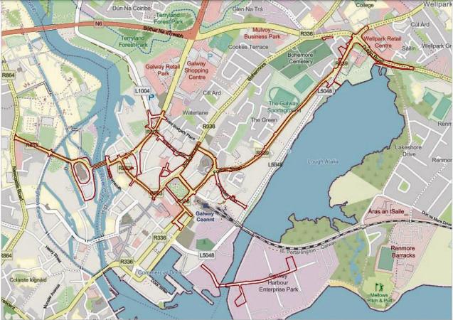
The new corridors, stretching from University Road to the Dublin Road, spell a disaster for motorists used to traversing the city to get work, home or education.
The modelling has predicted there will be a reduction in general traffic numbers of up to 1,350 vehicles per hour in morning peak hours on the westbound corridor when it opens and an average reduction of 283 vehicles per hour across all road links.
Meanwhile traffic forced to avoid the corridors will mean an increase in traffic on other link roads, anything between 102 and 944 more cars per hour during the morning rush.
Consultants say turning flows at the Kirwan Junction (Menlo Park Hotel) will increase by 7.7% and turning flows at junctions at either end of Quincentenary Bridge will increase by 13.5% and 12.4%.
Because all three junctions are operating at above 100% capacity, the An Bord Pleanála inspector accepted the assertion by Galway City Council that “the impact is considered to be negligible”.
“No junctions are predicted to experience significant effects,” she states.
The benefit that flows from opening up the corridors to encourage more people out of their cars will make it all worth it.
“…Modelling examines the potential for modal shift in the years 2023 and 2038 in relation to the am and pm peak times. The most significant shift is seen in the increase in people using the bus. In the year 2038 during the am peak in corridor 1 westbound it is predicted that sustainable travel modes will see an increase of 23%,” she points out.
Pictured: Map showing routes directly affected by the BusConnects Cross-City Link plan, which involves gving priority to buses, cyclists and pedestrians over a combined road length of 6.7km, stretching from UHG to the Dublin Road. Map copyright: ”OpenStreetMap” – Copyright and License | OpenStreetMap
More like this:
Major works on Ballybane and Castlepark Roads reach halfway point
This article first appeared on Galway Bay FMMajor ongoing works on the Ballybane and Castlepark R...
Local ETB learners to share stories in TG4 documentary
This article first appeared on Galway Bay FMTwo learners who upskilled through the Galway and Ros...
N67 Kinvara Active Travel Scheme under review due to significant challenges
This article first appeared on Galway Bay FMThe N67 Kinvara Active Travel Scheme is currently und...
Local TDs weigh in on €100k bike shelter upgrade at National Maternity Hospital
This article first appeared on Galway Bay FMLocal TDs have weighed in on plans to upgrade a bike ...
Final refusal for upgrades at Aran Islands Hotel on Inis Mór
This article first appeared on Galway Bay FMFinal refusal has been given for upgrade plans at the...
Education Minister urged to step up over 30 year delay to new school in Ballinasloe
This article first appeared on Galway Bay FMThe Education Minister is being urged to step up and ...
Plans for vet clinic in Oranmore village
This article first appeared on Galway Bay FMPlans have been lodged to transform a former hair sal...
Guitar men prove one of the highlights of outstanding Clifden Arts Festival
The White Horse Guitar Club, an eleven-strong all-male group who performed at Clifden’s Town Hall...
Galwegians dig deep to help Lions succeed
The outgoing President of Galway Lions Club has paid tribute the strength of community as the org...
Sign Up To get Weekly Sports UPDATES


