

Supporting Local News

Councillors zone land for residential use despite concerns over flooding
Published:
-

-
Author: Our Reporter
~ 3 minutes read
From this week's Galway City Tribune
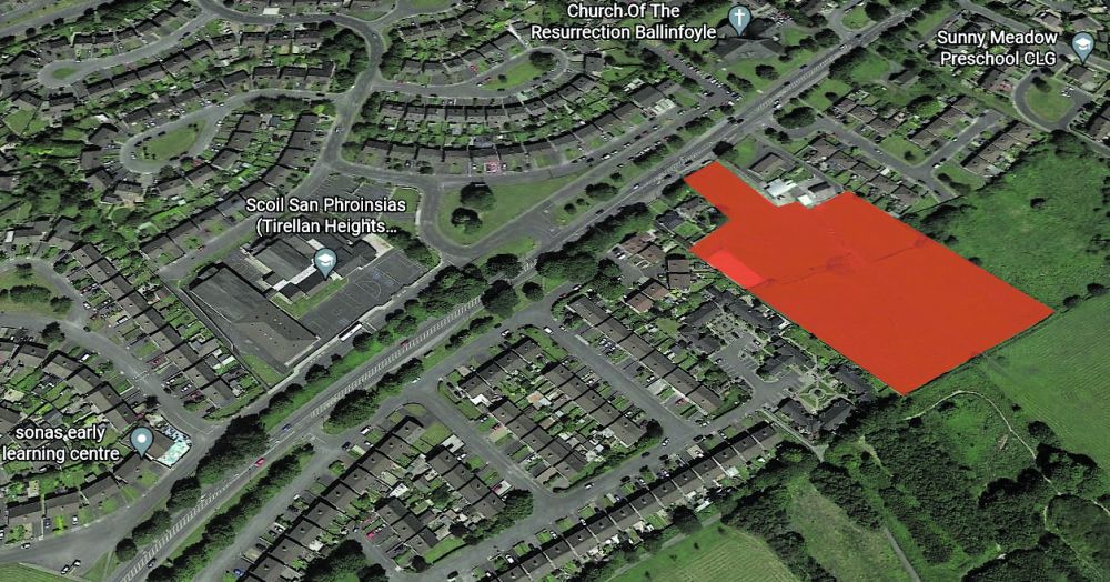

From the Galway City Tribune – Galway City Council has voted to allow for the future development of housing on a large parcel of land on the Headford Road (photographed and shaded red) which had previously been designated for recreation and “water-based activity”.
The land, which is situated below sea level, has been designated as being in a Flood Zone A area by the Office of Public Works (OPW), meaning that “vulnerable usage” such as housing should not be considered there.
BY ANDREW HAMILTON
During a meeting to approve the Galway City Development Plan 2023-29, councillors voted to reject the recommendation of its own Chief Executive, and in doing so opened the door for the future development of the 1.3-hectare (3.2-acre) site.
The land, which overlooks Terryland Forest Park, was also identified as a flood risk in the Catchment Flood Risk Assessment and Management report (CFRAM).
Cllr Frank Fahy (FG), proposed that the local authority should ignore the submissions of the OPW and the CFRAM report and rezone the land as residential.
“To say that this land should only be for water-based activity is not correct. To say that all of this land is a floodplain is also incorrect,” he said.
“It is below sea level but because of the dyke, it is not going to flood. There is a bit of land at the bottom [of the site] which is a flood risk, but I would imagine, if plans do go forward for this site, that area would be left open. Some of the land is borderline [flood risk] but not all of it.”
This article first appeared in the print edition of the Galway City Tribune. You can support our journalism by subscribing to the Galway City Tribune HERE. A one-year digital subscription costs just €89.00. The print edition is in shops every Friday.
This proposal was opposed by a number of councillors including Cllr Owen Hanley (SocDems).
“I would say that 80 per cent if not more [of the site] is in a flood risk area or is of concern. Also, if you develop part of it, you make the rest of it more at risk of flooding because the water is diverted there,” he said.
“While I respect that councillors are arguing in good faith, I am concerned about the way that we are discussing flood risks in this development plan overall.
“It would be inappropriate, given the advice that we have been given, to make this change.”
Despite these objections, councillors voted by a margin of 10 to 4 to rezone the land.
This decision may put the council on a collision course with the Minister of the Environment, Eamon Ryan, as the newly formed Office of Planning Regulators (OPR) had opposed this rezoning. The role of the OPR is to ensure that local development plans are in line with national regulations.
It is expected that the OPR may refer this decision to the Minister for the Environment, who has the power to overrule this decision by Galway City Council.
More like this:

Minister Eamon Ryan to visit city to inspect active travel measures and canvass for local elections
Minister Eamon Ryan will be in the city later today to canvass ahead of the upcoming local electi...

Biggest cruise liner of the year arrives in Galway Bay with up to 2,300 passengers
By Brendan Carroll The biggest cruise liner to visit the city this year sailed into Galway Bay...
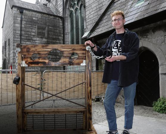
Medieval pillory is proving to be a big hit with visitors to St Nicholas’ Church
By Brendan Carroll A cruel form of punishment that left people who broke the law subject to r...

Youth Ballet West double bill
Youth Ballet West (YBW) will present a double bill at the Town Hall Theatre this Saturday and Sun...

Goal-shy Utd let Sligo men off hook in derby battle
Galway United 0 Sligo Rovers 0 GALWAY United played out their fifth scoreless draw of the s...

Rooftop bar and restaurant a key feature of €40m newest city hotel
A rooftop bar and restaurant with views to Galway Bay and the city will be a key feature of a new...

Edges of Empire the theme of Early Music Fest
This year’s Galway Early Music Festival, which begins on Friday, May 31, will explore how several...

Claregalway the venue for Fleadh Cheoil na Gaillimhe
Traditional musicians of all ages will gather in Claregalway from this Friday to Sunday, May 17-1...

Artist Pádraic showcases new work at Kennys’
Artist Pádraic Reaney returns to the Kenny Gallery in Galway City this Friday evening, May 17, wi...