

Supporting Local News

‘Bish’ told to go back to the drawing board on new school plans
Published:
-

-
Author: Enda Cunningham
~ 5 minutes read
From this week's Galway City Tribune

Management at the Bish secondary school have been told to go back to the drawing board on plans to relocate to Dangan – after transport authorities raised serious concerns about the site’s proximity to the route for the Galway City Ring Road.
Galway’s National Roads Project Office – part of the County Council and the lead authority on the Galway City Ring Road (GCRR) – has recommended that planning permission for the new school be refused on the ground its boundary is “in conflict” with the proposed road.
Acting Director of Services for Planning with Galway City Council, Uinsinn Finn, has now written to the school’s Board of Management, asking them to submit revised proposals. The City Council is responsible for assessing the school’s planning application.
Last month, the Galway City Tribune reported that Transport Infrastructure Ireland flagged the Ring Road route as being a stumbling block to the plan to relocate to University of Galway lands opposite Dangan Heights.
In its submission to planners, TII said the proposed development is at variance with national policy in relation to control of development “on or affecting national roads” and that the proposed development would “by itself or by the precedent it would set . . . adversely affect the operation and safety of the national road network”.
Referring to the development’s adjacency to the Ring Road route, they stated: “The proposed development could prejudice plans for the delivery of this scheme.”
TII said that ahead of making a decision, the Council should seek a traffic and transport assessment and a road safety audit in accordance with TII guidelines, to be paid for by the school.
“Any recommendations arising shall be incorporated in the proposed development by amendment to the existing planning application or as conditions of the permission, if granted.”
Separately, the Galway National Roads Project Office told city planners: “The proposed development boundary encroaches on a mainline embankment, drainage, a settlement pond and a junction on the N59. The boundary of the proposed development is in conflict with the GCRR and we are obliged to recommend a refusal for this reason.
“A Design Report for the junction on the N59 was not submitted as part of the application. Before a junction design on a national road can be finalised, a Design Report must be submitted to TII for approval.
“This process needs to be undertaken before we comment further on the application. However, we would like to note tat the proposed development includes for a right turn lane at the proposed signalised junction on the N59 which is not part of the GCRR, this is a potential point of conflict,” the Roads Office said.
The City Council has now written to the school’s Board of Management outlining the concerns about the road which were raised and asked them to liaise with TII, the GCRR Project Office and the Council’s own Transportation Section “before replying with a revised proposal to address these concerns”.
The Council added: “The City’s Heritage Officer has advised that the plans show no hedgerows or traditional field walls being retained and show no attempt to take account of a barrow on the site, which is a recorded monument”, asking that the school design teams also liaise with Dr Jim Higgins, the Heritage Officer.
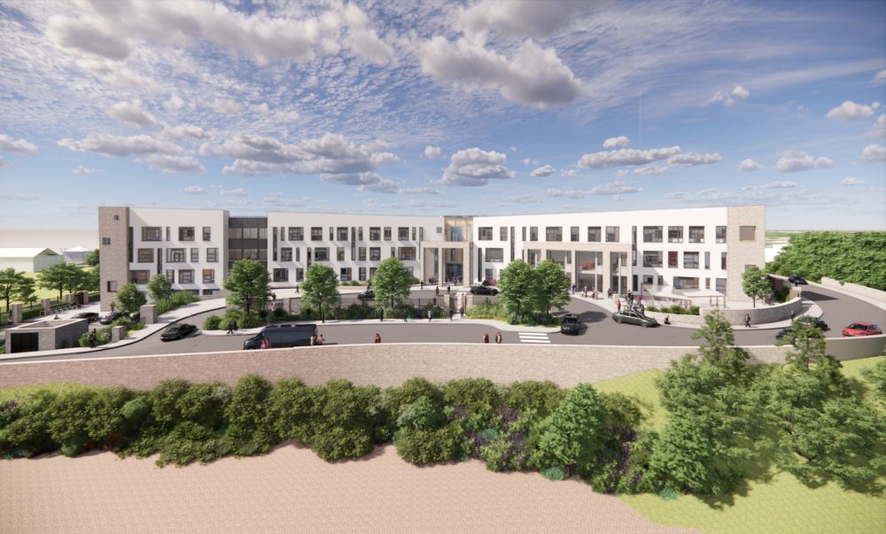
The proposal is for the school to build a state-of-the-art 11,134 square metre building comprising of classrooms, specialist room accommodation, a multi-purpose PE hall and a special needs unit spread over two to four storeys, with space for up to 1,000 students.
Externally, permission has been sought to construct five ball courts, 79 car parking spaces and 195 bicycle racks, all accessed from a new access road from the N59 at the junction of Circular Road.
Several objections based on concerns surrounding car traffic have been submitted to planners, including one from Dangan Heights residents Brian and Phil Langan who claim congestion in the area is already at “chaotic levels”, with parents from St James’ National School “resorting to using Dangan Heights to bypass the backlog”.
The NTA stated that they are concerned the proposed layout of the development “will encourage a high number of trips to the school by car”.
By basing the application on the premise that the school has “a significant local catchment”, the school has missed the opportunity to “make walking and cycling the most attractive modes of transport to the school”, the NTA submission stated.
The Newcastle Combined Community Association, submitted an objection to the application on the grounds that it would lead to people parking in estates nearby at drop-off and pick-up times, noting that the site is just around the corner from Bushypark National School. The association said it was no objecting to the school itself, rather the traffic implications.
Environmental and heritage watchdog An Taisce said it had concerns about the location “which is beyond reach of the current city bus network and which may not be easily accessible by appropriate active travel routes”.
Galway Cycling Campaign, in its submission, recommended improved footpaths and cycling routes along the N59 and to the Dangan Sports Campus; providing pedestrian or toucan crossings on the route; traffic calming in the area and measures to prevent illegal parking; and the removal of a potential rat-run at St Anne’s Lane.
In a submission to support the school’s development, Circular Road resident Joseph Tummon stated the benefits would far outweigh “any concerns that may arise RE additional traffic”.
The plans, if approved, would result in the Bish leaving its home of over 160 years in Nuns’ Island.
The Board of Management has reached an agreement with the University of Galway for the 6.5-acre site – it forms part of a land-swap deal under which UG would take ownership of the Nuns’ Island site.
The school authorities now have until the middle of February to submit the revised plans to the City Council.
More like this:

Sailor rescued from capsized boat
A sailor clinging to the upturned hull of his sailing boat in Clifden Bay had to be rescued by th...

Croí highlights need for national cardiac strategy
Croí, the Galway-based heart and stroke charity, has called for the urgent implementation of a ne...
Galway student in a class of her own at SciFest!
A Galway student has taken home the top prize at SciFest@TUS Athlone, one of Ireland’s largest re...

Updated Traffic Information For Connacht Senior Football Final
Gardai have issued an updated traffic plan ahead of this afternoon’s Connacht Senior Footba...

Galway Student named as finalist in National Legal Essay Competition
A Student from High Cross College Tuam made it to the final of the National Grainne O’Neill...

Public urged to support climber who is in Galway this weekend in an attempt to climb every mountain in Ireland
The people of Galway are urged to come out and lend their support to a man who has set an ambitio...

Cathaoirleach of Ballinasloe Municipal District Council concerned about the lack of applications for the filling of the position of GP in the Williamstown area.
The Cathaoirleach of Ballinasloe Municipal District Council Declan Geraghty has spoken of his con...

SVP conference marks 180 years of service to the most vulnerable in Irish society
Members from the Society of St Vincent de Paul in Galway were well represented alongside over 1,0...
Galway third-level student heads to work with Philippines’ Badjao community
A Clifden woman is all set to depart for Philippines on a four-week ethical volunteer programme w...